
Robert lakes


Contact
Robert lakes
Chamrousse 2250
38410
Chamrousse
Presentation
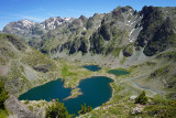
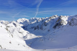
Within a mineral setting, these deep blue lakes are easily accessible by gondola.
The four Robert lakes are located at an altitude of 1,998 meters, and occupy a 28-hectare area at the bottom of the basin of a natural cirque. They are bordered and dominated to the east by Petit Van (2,439 meters), Grand Van (2,448 meters) and Grand Sorbier (2,526 meters).
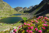
In summer, you can enjoy numerous hikes at the gateway to the high mountains, as well as fishing for rainbow trout and Arctic grayling in the Robert lakes. It's also the only lake in Chamrousse where bathing is permitted (note: altitude lake = cold water + fauna and flora to be respected).
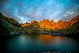
In winter, you can go ice diving here, and discover a ski slope and lift named after the lake.
The 2,677 ha site is also part of the Natura 2000 network, under the name "Cembraie, pelouses, lacs et tourbières de Belledonne, de Chamrousse au Grand Colon".
In summer, you can enjoy numerous hikes at the gateway to the high mountains, as well as fishing for rainbow trout and Arctic grayling in the Robert lakes. It's also the only lake in Chamrousse where bathing is permitted (note: altitude lake = cold water + fauna and flora to be respected).
In winter, you can go ice diving here, and discover a ski slope and lift named after the lake.
The 2,677 ha site is also part of the Natura 2000 network, under the name "Cembraie, pelouses, lacs et tourbières de Belledonne, de Chamrousse au Grand Colon".
Lacs Robert: Natura 2000 site/classified site/registered site
❌ Prohibited: fire (except camping stove)
✔️ Authorised: bivouac from sunset to sunrise, and fishing.
❌ Prohibited: fire (except camping stove)
✔️ Authorised: bivouac from sunset to sunrise, and fishing.
Opening periodAll year round daily.
General informations
- Visits :
- Open for visits
- Period :
- Fall
- Summer
- Winter
- Spring
- Open year-round
- Classifications :
- classifications
Prices
Free access.
Destination
Lacs Robert
Chamrousse 2250
38410
Chamrousse
GPS coordinates
Latitude : 45.130832
Longitude : 5.914207
From Grenoble: car or bus (+ cable car ascent) + hike
Resort road access: Rocade Sud > exit no. 2 "Uriage" > Route départementale 111 (RD 111) Seiglières side.
Recommended parking: parking Henry Duhamel (P7), avenue Henry Duhamel (200 meters and about 2 minutes' walk - pay attention in winter).
Public transport :
Chamrousse 1650 - Recoin stop:
- regular bus service all year round: N93 (to/from Grenoble), "Chamrousse 1650" stop (merger of former T87, Transaltitude, Destination neige Skibus / nature Estibus 707).
Good to know - another stop less than 500m away (Place de Belledonne, near the Tourist Office):
- transport by reservation on weekdays excluding public holidays: Flexo 57 (to/from Uriage), "Chamrousse - Le Recoin" stop (former TAD TouGo - line G701)
- resort shuttle in winter and summer: "Télécabine (1650)" stop (to/from Chamrousse 1750 - Roche Béranger and Chamrousse 1600 - plateau de l'Arselle/nordic area).
We also suggest...


Chamrousse 1650
-
Route type :
-
Difficulty :
-
Walking time (round trip) :
- half day
- by the day


-
- Bus stop 500 m away


-
Route type :
-
Difficulty :
-
Walking time (round trip) :
- half day
- by the day
-
- Bus stop 500 m away


Chamrousse 2250
-
Route type :
-
Difficulty :
-
Walking time (round trip) :
- half day
-
- Help for client/transport


Chamrousse 2250
-
- Help for client/transport


-
- Help for client/transport

Chamrousse 2250
-
- Help for client/transport


Altitude lake 7 natural wonders
-
Classifications :
- classifications


Chamrousse 1650
-
Route type :
-
Difficulty :

-
- Bus stop 500 m away


Chamrousse 1650
-
Route type :
-
Difficulty :
-
- Bus stop 500 m away


Chamrousse 2250
-
Route type :
-
Difficulty :
-
Walking time (round trip) :
- half day
-
- Help for client/transport


Altitude lake 7 natural wonders Baignade interdite Bivouac interdit de début mai à fin octobre
-
Classifications :
- Sensitive natural areas Spanish
- classifications


Chamrousse 2250
-
Route type :
-
Difficulty :
-
Walking time (round trip) :
- half day
-
- Help for client/transport


Chamrousse 1650 Chamrousse 1750
-
Route type :
-
Difficulty :
-
Walking time (round trip) :
- by the day

-
- Bus stop 500 m away

-
Route type :
-
Difficulty :
-
Walking time (one way) :
- 2 days or more / travelling
-
- Bus stop 500 m away


Chamrousse 1650
-
Route type :
-
Difficulty :
-
Walking time (round trip) :
- by the day
-
- Bus stop 500 m away
-
Route type :
-
Difficulty :
-
Walking time (one way) :
- 2 days or more / travelling
-
- Bus stop 500 m away


Chamrousse 2250
-
- By reservation only