
Arselle climbing site
Pics
Pics


Contact
Arselle climbing site
Chamrousse 1700
38410
Chamrousse
Presentation
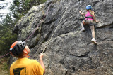
Arselle school climbing site (Village du Bachat)
Rocky ridge appropriate for beginners thanks to its close holds and its routes level (40 routes from 3 to 5c/6a)
Rocky ridge appropriate for beginners thanks to its close holds and its routes level (40 routes from 3 to 5c/6a)
Practical information:
Location: Chamrousse 1700
Practice level: beginner (3 to 5c)
Approach time: 10 mn
Best period: May to October
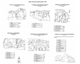
- Massif: Belledonne
- IGN map: 3335 OT
- Altitude: 1664 m
- Rock: gneiss
- Number of routes: 40
- Minimum route height: 15 m
- Maximum route height: 20 m
- Climbing style: walls, slabs with rulers
- Boulder orientation: east
- Teams: Marc Durdan, Yves Gersquiers, Claude Vigier...
Because of the peat bog that makes up the plateau, and its landscape, botanical and faunal interest, the Arselle plateau is a natural area protected by an arrêté préfectoral de protection de biotope. The aim of this decree is to preserve the site and the plant and animal species present.
There are therefore a few rules to be observed to help protect the site: fire, wild camping, bivouacking, gathering and dumping waste are strictly forbidden. Please stay on the path that circles the area, as it is forbidden to go onto the plateau in order to preserve the fragile environments.
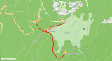
Approach to climbing site:
From the parking lot on the Arselle plateau, walk down in front of the terrace of the Salinière restaurant.
The rock is on the other side of the plateau. You are entering a sensitive natural area (ENS).
Do not cross the plateau on foot; you must go around the edge of the forest.
From the terrace, take the cross-country ski trail to the right, heading west until you reach the edge of the forest. Then take the Brimbelles trail to the left, heading south.
The track becomes a path that leads to the foot of a hump inhabited by tall spruce trees. The Rocher de l'Arselle (Arselle rock) is just behind, and you just need to go around the hump to the right, following a small path.
Location: Chamrousse 1700
Practice level: beginner (3 to 5c)
Approach time: 10 mn
Best period: May to October
- Massif: Belledonne
- IGN map: 3335 OT
- Altitude: 1664 m
- Rock: gneiss
- Number of routes: 40
- Minimum route height: 15 m
- Maximum route height: 20 m
- Climbing style: walls, slabs with rulers
- Boulder orientation: east
- Teams: Marc Durdan, Yves Gersquiers, Claude Vigier...
Because of the peat bog that makes up the plateau, and its landscape, botanical and faunal interest, the Arselle plateau is a natural area protected by an arrêté préfectoral de protection de biotope. The aim of this decree is to preserve the site and the plant and animal species present.
There are therefore a few rules to be observed to help protect the site: fire, wild camping, bivouacking, gathering and dumping waste are strictly forbidden. Please stay on the path that circles the area, as it is forbidden to go onto the plateau in order to preserve the fragile environments.
Approach to climbing site:
From the parking lot on the Arselle plateau, walk down in front of the terrace of the Salinière restaurant.
The rock is on the other side of the plateau. You are entering a sensitive natural area (ENS).
Do not cross the plateau on foot; you must go around the edge of the forest.
From the terrace, take the cross-country ski trail to the right, heading west until you reach the edge of the forest. Then take the Brimbelles trail to the left, heading south.
The track becomes a path that leads to the foot of a hump inhabited by tall spruce trees. The Rocher de l'Arselle (Arselle rock) is just behind, and you just need to go around the hump to the right, following a small path.
It is your responsibility to assess your climbing ability. Respect safety rules. Check your equipment.
Opening periodFrom 01/05 to 31/10 daily.
Open all year round - accessible depending on snow conditions.
Open all year round - accessible depending on snow conditions.
Classification, Label
- Facilities and services :

General informations
- Services :
- Pets allowed
- Grouping by age (EN) :

- Grouping by age (EN)
Prices
Free access.
Itinéraire
 Departure/Arrival
 Point of interest
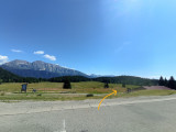
Parking lot along the D111 departmental road, then access on foot via the pedestrian link to the Arselle plateau.
Public transport - Chamrousse 1600 - Plateau de l'Arselle stop:
- resort shuttle: "Plateau de l'Arselle Domaine nordique (1600)" stop (to/from Chamrousse 1650 - Recoin and Chamrousse 17500 - Roche Béranger)
Public transport - Chamrousse 1750 - Roche Béranger stop:
- regular bus service all year round: N93 (to/from Grenoble), "Chamrousse 1750" stop [merger of former bus routes T87, Transaltitude and Destination nature Skibus / Estibus 707].
- bus line / shuttle on reservation weekdays excluding public holidays: Flexo 57 to/from Uriage [former TAD TouGo transport on demand - line G701].
- Internal criteria :
- Chamrousse 1700
We also suggest...


