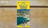
Belledonne and Chamrousse paths map - €5

Chamrousse guidebook belledonne mountain hike resort summer isere french alps franceChamrousse guidebook belledonne mountain hike resort summer isere french alps franceBelledonne and Chamrousse paths map
Office de Tourisme
Place de Belledonne
38410
CHAMROUSSE
mail / message
FICHE_INFO_SIMPLE_ECRIRE_MESSAGE
Fields with an asterisk * must not be left blank
My request
Your Contact Details
The collected information on this form are recorded in a computerized file by the Tourist Office of Chamrousse and the tourism professional referenced, co-responsible for processing, in order to respond to your request. The legal basis for processing is consent. The collected data will be communicated only to the following recipients: the services of the Tourist Office of Chamrousse and the tourism professional referenced.

You can access, rectify, erase or exercise your right to restrict the processing of your data. You can withdraw your consent to the processing of your data at any time. Visit National Committee for Information Technology and Civil Liberties (CNIL) website for more information about your rights.
To exercise these rights or for any questions about the processing of your data, you can contact our Data Protection Officer (DPO) by email by using the DPO contact form. If you have the feeling, after contacting us, that your rights are not respected, you can submit a complaint to the CNIL.

Presentation

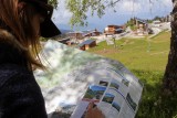
Belledonne and Chamrousse hiking, mountain biking and horsing tracks map
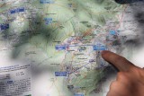
The Grésivaudan map-guide offers 900km of signposted routes and 80 commented circuits for walking, horse riding and mountain biking.
Between Grenoble and Chambéry, in the foothills of the Belledonne. Produced by the Département de l'Isère.
Map at 1: 35 000.
 

    Tarifs

    5€ one item
    We also suggest...