
Chamrousse 1750 - Arselle plateau, via the connecting trail
Pics
Pics


Contact
Chamrousse 1750 - Arselle plateau, via the connecting trail
478 Avenue du Père Tasse
Chamrousse 1750
38410
Chamrousse
- Spoken language(s) :
- French
Presentation
Chamrousse 1750 <-> "Arselle" plateau
Departure: Chamrousse 1750 Tourist Office.
In high season chose your way back: take the free shuttle or walk on the connecting path
Departure: Chamrousse 1750 Tourist Office.
In high season chose your way back: take the free shuttle or walk on the connecting path
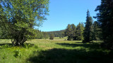
A relaxing walk across the woods, where you will contemplate the Grenoble valley, discover a mixed forest (spruce trees, fir trees, goat willows, green alders, sorbs, maples and birches). You might see a roe deer eating on the edge of the path, or follow the tracks left by our forest hosts.
Please note: the Arselle plateau is a protected area (peat bog classified as an APPB - Arrêtés Préfectoraux de Protection Biotope), so there are a few rules to follow to help protect it. Fire, wild camping, bivouac, picking and dumping of waste are strictly forbidden. Please stay on the path around it, it is forbidden to go on the plateau in order to preserve the fragile environment.
Please note: the Arselle plateau is a protected area (peat bog classified as an APPB - Arrêtés Préfectoraux de Protection Biotope), so there are a few rules to follow to help protect it. Fire, wild camping, bivouac, picking and dumping of waste are strictly forbidden. Please stay on the path around it, it is forbidden to go on the plateau in order to preserve the fragile environment.
Animals allowed: dogs are allowed on all trails on a leash (but please avoid taking them to the Arselle plateau, which is a sensitive natural area).
The shepherd who works in Chamrousse in summer does not have patous.
Trail groomed in winter, snowshoeing not compulsory but recommended depending on weather and snow conditions.
The shepherd who works in Chamrousse in summer does not have patous.
Trail groomed in winter, snowshoeing not compulsory but recommended depending on weather and snow conditions.
Opening periodAll year round daily.
Download
Classification, Label
- Facilities and services :
- National :
- FFRandonnée


General informations
- Route :
- Services :
- Pets allowed
- Grouping by age (EN) :

")
")
")
")

Equipments & Services
- Leisure facilities :
- Picnic area
- Parking :
- Parking facilities nearby
Prices
Free access.
Itinéraire
 Departure/Arrival
 Point of interest
Circuit n° 1
Public transport - stop Chamrousse 1750 - Roche Béranger :
- regular bus service all year round: N93 (to/from Grenoble), stop "Chamrousse 1750" [merger of former bus routes T87, Transaltitude and Destination nature Skibus / Estibus 707].
- bus line / shuttle on reservation weekdays excluding public holidays: Flexo 57 to/from Uriage [former TAD TouGo transport on demand - line G701].
- winter season resort shuttle: "Centre Commercial (1750)" stop (to/from Chamrousse 1650 - Recoin and Chamrousse 1600 - plateau de l'Arselle/nordic area)
Further information at https://www.itinisere.fr
- Internal criteria :
- Chamrousse 1750
- Chamrousse 1600
- Mobility :
- Bus stop 500 m away
- Shuttle stop 300 m away
We also suggest...


