
Croix de Chamrousse footpaths and lookouts - summer
Videos / Pics
Videos / Pics


Contact
Croix de Chamrousse footpaths and lookouts - summer
Croix de Chamrousse
Chamrousse 2250
38410
Chamrousse
- Spoken language(s) :
- French
- English
Presentation
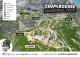
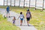
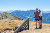
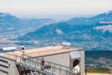
Hiking trails to the top of the resort, at the Croix de Chamrousse, over 2250 m above sea level. Discover lookouts with exceptional views of the surrounding mountains, panoramic orientation tables and geological panels.
Several routes are available in summer (and winter) at Panoramic Park:
- Oisans trail:
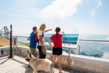
- Points of interest: panoramic views, geology panels, lookout point and panoramic tables on the Oisans massif.
- Distance: approx. 300 m / Type of route: round trip / Vertical rise: approx. 5 m / Duration: approx. 10-15 minutes / Difficulty: green - easy
- Route: access path to the belvedere from the central picnic area, passing by the arrival point of the Amoureux and Robert Lakes chairlifts.
[TEMPORARILY CLOSED] - Grenoble loop :
- Point of interest: Grenoble / Grésivaudan rooftop with panoramic tables, views over the city of Grenoble and its valley, as well as the Chartreuse and Vercors ranges + giant zip-line departure point.
- Distance: approx. 500 m / Type of route: loop / Vertical rise: approx. 30 m / Duration: approx. 15-20 minutes / Difficulty: blue - intermediate
- Route: gondola > picnic area > rooftop > station view trail > La Croix restaurant > gondola
- Belledonne loop :
- Points of interest: panoramic view of the Belledonne mountains (Chamrousse at the southern tip) and the Robert lakes, Himalayan footbridge and Belledonne lookout.
- Distance: approx. 900 m / Type of route: loop + out-and-back section / Ascent: (information to follow) / Duration: 40-45 minutes / Difficulty: blue - intermediate (beware of the vertiginous footbridge, but you can take the path below to avoid it if you're afraid of heights).
- Route: gondola > picnic area > Himalayan footbridge (or path to avoid it if you're afraid of heights) > Belledonne lookout > Himalayan footbridge (or path) > picnic area
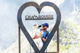
- Cross loop :
- Point of interest: monument in the form of a cross symbolizing the summit of the station.
- Distance: approx. 100 m / Type of route: loop / Vertical rise: approx. 2 m / Duration: 2-3 minutes / Difficulty: green - easy
- Route: short path from the central picnic area
Plus :
- a picnic area: tables with benches, individual trestle chairs, plancha (11am-3.30pm on days when the Croix gondola is open during the tourist season only), waste sorting garbage cans and panels on Chamrousse's stones and flowers
- a free "Chamrousse Explor games" game (start at the bottom of the resort at the Maison du patrimoine et de l'environnement in Chamrousse 1650 - Recoin)
- and, of course, the unmissable La Croix restaurant.
- Oisans trail:
- Points of interest: panoramic views, geology panels, lookout point and panoramic tables on the Oisans massif.
- Distance: approx. 300 m / Type of route: round trip / Vertical rise: approx. 5 m / Duration: approx. 10-15 minutes / Difficulty: green - easy
- Route: access path to the belvedere from the central picnic area, passing by the arrival point of the Amoureux and Robert Lakes chairlifts.
[TEMPORARILY CLOSED] - Grenoble loop :
- Point of interest: Grenoble / Grésivaudan rooftop with panoramic tables, views over the city of Grenoble and its valley, as well as the Chartreuse and Vercors ranges + giant zip-line departure point.
- Distance: approx. 500 m / Type of route: loop / Vertical rise: approx. 30 m / Duration: approx. 15-20 minutes / Difficulty: blue - intermediate
- Route: gondola > picnic area > rooftop > station view trail > La Croix restaurant > gondola
- Belledonne loop :
- Points of interest: panoramic view of the Belledonne mountains (Chamrousse at the southern tip) and the Robert lakes, Himalayan footbridge and Belledonne lookout.
- Distance: approx. 900 m / Type of route: loop + out-and-back section / Ascent: (information to follow) / Duration: 40-45 minutes / Difficulty: blue - intermediate (beware of the vertiginous footbridge, but you can take the path below to avoid it if you're afraid of heights).
- Route: gondola > picnic area > Himalayan footbridge (or path to avoid it if you're afraid of heights) > Belledonne lookout > Himalayan footbridge (or path) > picnic area
- Cross loop :
- Point of interest: monument in the form of a cross symbolizing the summit of the station.
- Distance: approx. 100 m / Type of route: loop / Vertical rise: approx. 2 m / Duration: 2-3 minutes / Difficulty: green - easy
- Route: short path from the central picnic area
Plus :
- a picnic area: tables with benches, individual trestle chairs, plancha (11am-3.30pm on days when the Croix gondola is open during the tourist season only), waste sorting garbage cans and panels on Chamrousse's stones and flowers
- a free "Chamrousse Explor games" game (start at the bottom of the resort at the Maison du patrimoine et de l'environnement in Chamrousse 1650 - Recoin)
- and, of course, the unmissable La Croix restaurant.
Opening periodFrom 29/05 to 31/10 daily.
Easy access via the Croix gondola in Chamrousse 1650 - Recoin in winter and summer.
Out of season access only by hiking (about 2 hours one way).
Easy access via the Croix gondola in Chamrousse 1650 - Recoin in winter and summer.
Out of season access only by hiking (about 2 hours one way).
Classification, Label
- Facilities and services :

General informations
- Route :
- Services :
- 3 Years maximum
- Services :
- Pets allowed
- Grouping by age (EN) :

")
")

Equipments & Services
- Leisure facilities :
- Picnic area
- Orientation board
Prices
Free of charge. Easy access via the Croix cable car from Chamrousse 1650 - Recoin: in summer, pedestrian pass (one-way or round-trip).
Itinéraire
 Departure/Arrival
 Point of interest
Resort road access from Grenoble: Rocade Sud > exit no. 2 "Uriage" > Route départementale 111 (RD 111) Seiglières side.
Recommended parking: Parking Henry Duhamel (P7), avenue Henry Duhamel (200 m from the gondola, approx. 2 minutes' walk).
Access to the top of the resort at Croix de Chamrousse (Chamrousse 2250) via the Croix à Chamrousse 1650 - Recoin gondola.
Public transport - Chamrousse 1650 - Recoin stop:
- regular bus service all year round: N93 (to/from Grenoble), "Chamrousse 1650" stop [merger of former T87, Transaltitude, Destination neige Skibus / nature Estibus 707].
Good to know - another stop less than 500m away (Place de Belledonne, near the Tourist Office):
- bus line / shuttle by reservation on weekdays excluding public holidays: Flexo 57 (to/from Uriage), "Chamrousse - Le Recoin" stop [former TAD TouGo - line G701].
- Internal criteria :
- Chamrousse 2250
We also suggest...


