
Car-free hike - Crossing from Chamrousse to Vizille
Pics
Pics


Contact
Car-free hike - Crossing from Chamrousse to Vizille
Arrêt transport en commun Roche Béranger - Avenu
Chamrousse 1750
38410
Chamrousse
Presentation
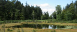
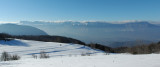
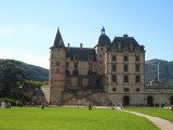
A descent to the Château de Vizille, through the different levels of the alpine forest, to discover a protected peat bog, with views of the mountains and their isolated hamlets.
Itinerary by public transport offered by Alpes Là.
Itinerary by public transport offered by Alpes Là.
Opening periodFrom 01/05 to 31/10 daily.
Hike to do in summer season, presence of late snow.
Subject to favorable snow and weather conditions.
Hike to do in summer season, presence of late snow.
Subject to favorable snow and weather conditions.
Download
Classification, Label
- Facilities and services :

General informations
- Route :
- Services :
- 5 Years maximum

")
")
")
")
Equipments & Services
- Parking :
- Parking facilities nearby
Prices
Free access. Public transport ticket price at your expense.
Itinéraire
 Departure/Arrival
 Point of interest
From Grenoble station to Chamrousse: M Réso N93, Chamrousse 1750 - Roche Béranger stop (duration 1h15 min)
Return from Vizille Place du Château to Gières: Bus M Réso 23, Gières Gare stop (30 min.)
Return from Vizille Place du Château to Gières: Bus M Réso 23, Gières Gare stop (30 min.)
- Internal criteria :
- Chamrousse 1750
- Mobility :
- Bus stop 500 m away
We also suggest...
