
Chamrousse site - Aiguille take-off area
Pics
Pics


Contact
Chamrousse site - Aiguille take-off area
Chamrousse 1650
38410
Chamrousse
- Spoken language(s) :
- French
Presentation
The Chamrousse site is managed by Air Ailes Chamrousse Vol Libre. For professional supervision, please contact the Corole paragliding school.
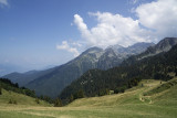
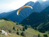
Free-flight take-off zone near the Chamrousse resort (at 1839 meters).
Flights can be made at any time of day. Dangerous in strong winds, especially north-easterly and south-westerly.
Access by car to the free-flight parking lot (Chamrousse 1650), then about 10 minutes on foot.
L'Aiguille is a 4-way pyramidal take-off zone that allows flights from 8am to around 9pm. It is positioned on a north/south ridge and looks westwards.
A FFVL beacon is available from April to October (it is removed in winter).
An orienteering table, windsock and weather beacon are available on site.
Please respect parking areas, prohibited zones and site cleanliness.
In the event of an accident, call 18 or 112.
Landing : Uriage
Orientation: Latitude 45.1 - Longitude 5.883
Equipment: windsock, weather beacon, webcam and FFVL Chamrousse beacon (143 9 874 MHz)
Accessibility :
- Car from Grenoble: 35 km - 45 min
- Bus: T87 (formerly Transisère 6010) - Grenoble-Chamrousse and TouGo 707 Grenoble-Chamrousse
- Walking distance from take-off: 13 min, 0.900 km, 110 D+.
Opening periodAll year round daily.
Subject to favorable weather.
Subject to favorable weather.
Tarifs
Free access.
Itinéraire
 Departure/Arrival
 Point of interest
Access possible by bus - Chamrousse 1650 - Recoin stop + approach walk :
- bus / shuttle service by reservation all year round (weekdays only and excluding public holidays) with Flexo 57 to/from Uriage (near Richardière landing zone) [former TAD TouGo transport on demand - line G701]: small paragliding bag equivalent to large hiking bag ok in shuttle trunk - no luggage compartment
- regular bus service with N93 to/from Grenoble: paragliding bag in hold [merger of former T87, Transaltitude, Skibus / Estibus 707 services].
By car: from Uriage, take the road towards the Chamrousse resort (RD 280, then right on the RD111), as far as Chamrousse 1750 - Roche Béranger (on the Luitel side) or Chamrousse 1650 - Recoin (on the Seiglières side).
We also suggest...


