
Chamrousse 1650 - Aiguille


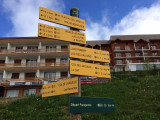
Departure point: Chamrousse 1650 - Recoin tourist office.
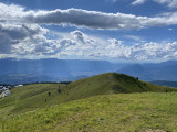
A short uphill walk with a well-deserved view of Grenoble and the Grésivaudan valley.
For the round trip, allow 45 minutes (1.4km).
A short uphill walk with a well-deserved view of Grenoble and the Grésivaudan valley.
For the round trip, allow 45 minutes (1.4km).
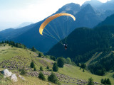
Admire the paragliders as they take to the skies, contemplate the peaks that surround you, learn about the history of Grenoble and discover the story of the bête du Grésivaudan by consulting the reading tables at the top of the Aiguille.
Not to be missed! Continue on for 300m to reach the new #Chamrousse photo spot, just above the Col de l'Aiguille (at the arrival of the Casserousse chairlift, altitude 1870m). Allow a further 15 minutes' walk, 40m of ascent/10m of descent.
Not to be missed! Continue on for 300m to reach the new #Chamrousse photo spot, just above the Col de l'Aiguille (at the arrival of the Casserousse chairlift, altitude 1870m). Allow a further 15 minutes' walk, 40m of ascent/10m of descent.
Suitable equipment recommended (sloping, unshaded route)
Opening periodFrom 01/05 to 30/11 daily.
Subject to snow conditions.
Subject to snow conditions.
Contact
Chamrousse 1650 - Aiguille
42 place de Belledonne
Chamrousse 1650
38410
Chamrousse
- Spoken language(s) :
- French
- English
Route
 Type of route:
:
Aller / Itinerance
Type of route:
:
Aller / Itinerance
 0.7
km (distance)
0.7
km (distance)
 25
minutes (session length)
25
minutes (session length)
 160
metres (positive drop)
160
metres (positive drop)
 Chamrousse 1650 - Recoin
 Departure/Arrival
 Point of interest
Circuit n° 1
Resort road access from Grenoble: Rocade Sud > exit no. 2 "Uriage" > Route départementale 111 (RD 111) Seiglières side.
Recommended parking: Parking Henry Duhamel (P7), avenue Henry Duhamel (200 m, approx. 2-minute walk).
Public transport - Chamrousse 1650 - Recoin stop:
- regular bus service all year round: N93 (to/from Grenoble), "Chamrousse 1650" stop [merger of former T87, Transaltitude, Destination neige Skibus / nature Estibus 707].
Good to know - another stop less than 500m away (Place de Belledonne, near the Tourist Office):
- bus line / shuttle service by reservation on weekdays excluding public holidays: Flexo 57 (to/from Uriage), "Chamrousse - Le Recoin" stop [former TAD TouGo - line G701].
- winter season resort shuttle: "Télécabine (1650)" stop (to/from Chamrousse 1750 - Roche Béranger and Chamrousse 1600 - plateau de l'Arselle/nordic area)
- Mobility :
- Bus stop 500 m away
General informations
- Services :
- Pets allowed
- Additional openings :
- Depending on snow conditions
Equipments & Services
- Parking :
- Parking lot
- Parking facilities nearby
- Free car park
About
Panoramic view of the Grenoble Valley with paragliding take-off site.
Pics
Pics


We also suggest...


