GR®738 - High crossing of Belledonne
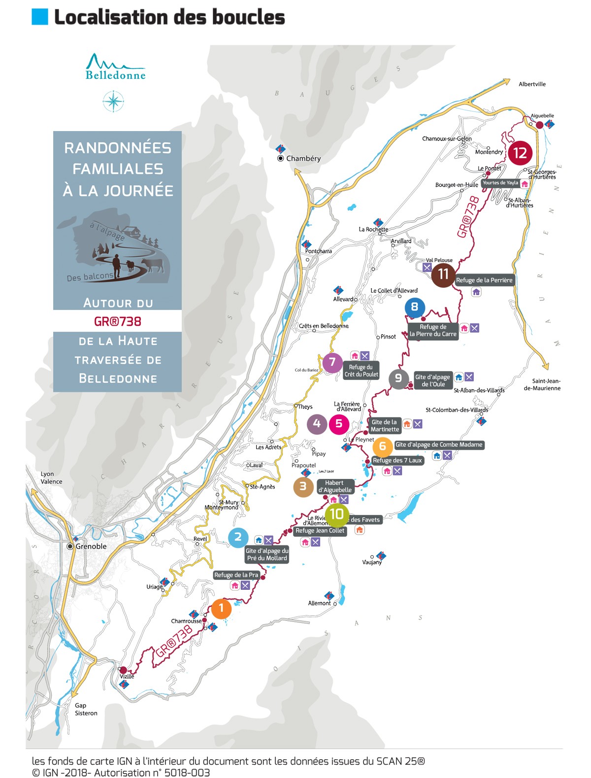
This new GR® in Belledonne, approved in June 2018, is 130 km long and has no less than 10,000 metres of vertical drop.
For the sportiest, the High Crossing in 11 stages is a complete crossing of the mountain chain from the bottom of the valley to more than 2,000 m of height, an immersion in a wild and surprising massif, between pastures and lakes.
But there is one for all practices, with itinerant routes of 2 to 4 days and full-day loops, like the discovery of the pastures in Chamrousse, 1st loop of this crossing of Belledonne.
All news on High crossing of Belledonne website (caution only in French).
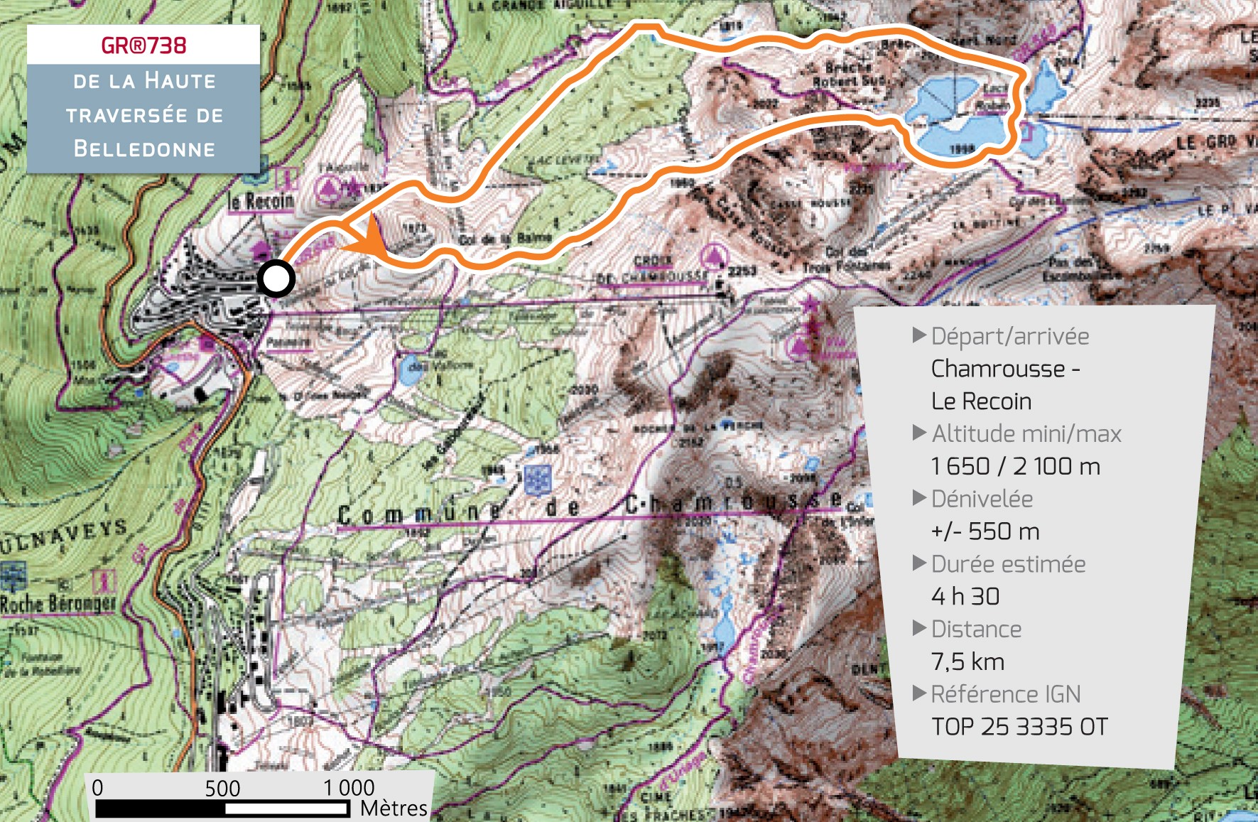
1) Full-day loop of Chamrousse: The pasture
Discover or rediscover the exceptional landscapes that this loop offers, from the clear waters of the Robert lakes and the surrounding lakes, to the edge of the upper limit of the alpine pastures.
- Departure/Arrival: Chamrousse 1650 - Le Recoin. Park near the Tourist office.
- Estimated time: 4h30
- Distance: 7.5 km
- Vertical drop: +/- 550 m
- Minimum/max height: 1,650 / 2,100 m
- IGN Reference: TOP 25 3335 OT
Chamrousse loop trail:
The start of this loop is in the heart of Chamrousse – Le Recoin, in an almost urban environment. Very quickly, we enter the resort via the GR®738 towards the Balme pass.
The road then continues to the edge of the Robert Lakes. The atmosphere becomes much more mineral and the black rock contrasts with the emerald green of the water.
After walking around the two largest lakes, you escape through the northern breach and wind between the blocks before reaching the edge of the Pourettes Lake. This part of the route has several small lakes like this one.
After passing the Pourettes Lake, follow the path towards the starting point. Just before going down to Le Recoin, a superb panorama emerges on the Vercors. On the far, the Mont Aiguille stands alone.
Discover all the details of this loop but also the other loops of the GR®738 on the website of the Haute traversée de Belledonne (only in French).
2) Stage 10 of the High crossing of Belledonne: From one world to another
The high crossing of Belledonne - GR®738 has for penultimate stage (or 2nd stage depending on the direction of the route), the crossing of Chamrousse via the refuge de la Pra.
- Departure (or arrival) : "Refuge de la Pra"
- Arrival (or departure): Chamrousse 1650 - Le Recoin
- Estimated time: 3h15
- Distance: 9.5 km
- Estimated vertical drop: + 450 m / -880 m
- Departure altitude: 2109m
- Arrival altitude: 1650 m
- IGN Reference: TOP 25 3335 OT
This route goes through the old GR®549 to the Robert Lakes. Go to Le Recoin via the Pourettes Lake.
From the refuge, you walk down through the pastures punctuated by ponds, streams and many lakes with crystal clear waters. The mountain hosts in these magical places a local herd of nearly 1500 sheep. Up to the Robert Lakes, stretches the uninterrupted and majestic string of the peaks and lakes of Belledonne, where shepherds and hikers regularly meet. You enter a protected area, Natura 2000. The trail crosses a characteristic area with its sparse forest of cembro pines, a rare coniferous species, and pines. After the Robert lakes, you can easily reach the resort of Chamrousse. A herd of 1200 sheep from the south of France and some heifers graze there from June to October.
In Chamrousse, you will find a more lively life and you will be able to enjoy the entertainments and events of the moment.
La Pra refuge de la Pra - Chamrousse or Freydières access
To get more informations about the openning of the retreat houses in Belledonne, please see the website (in french only). Or feel free to contact the Espace Belledonne or the French Federation of Alpine and Mountain Clubs.
Regarding to retreat houses booking, thank you to contact directly each of its, as soon as they are open.
Discover all the stages of the GR®738 on the website of the Haute traversée de Belledonne.


