
Loop of the Arselle plateau running trail


Green level running trail around Arselle plateau.
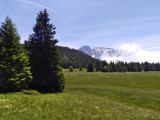
Departure: Arselle plateau in Chamrousse 1600.
Departure: Arselle plateau in Chamrousse 1600.
Easy running trail. Estimated running time based on an average speed of 7km/h.
⚠ Warning: the Arselle plateau is a protected area (peat bog classified as an APPB - Arrêtés Préfectoraux de Protection Biotope), so there are a few rules to respect to help protect it. Fire, wild camping, bivouac, picking and dumping of waste are strictly forbidden. Please stay on the path around it, it is forbidden to go on the plateau in order to preserve the fragile environment.
⚠ Warning: the Arselle plateau is a protected area (peat bog classified as an APPB - Arrêtés Préfectoraux de Protection Biotope), so there are a few rules to respect to help protect it. Fire, wild camping, bivouac, picking and dumping of waste are strictly forbidden. Please stay on the path around it, it is forbidden to go on the plateau in order to preserve the fragile environment.
Opening periodFrom 15/06 to 30/09.
Contact
Loop of the Arselle plateau running trail
Chamrousse 1600
38410
Chamrousse
- Spoken language(s) :
- French
Route
 Type of route:
:
BOUCLE
Type of route:
:
BOUCLE
 3.6
km (distance)
3.6
km (distance)
 31
minutes (session length)
31
minutes (session length)
 94
metres (positive drop)
94
metres (positive drop)
 94
metres (negative drop)
94
metres (negative drop)
 Arselle plateau
 Chamrousse 1600 - Plateau de l'Arselle
 Departure/Arrival
 Point of interest
Circuit n° 1
Station road access from Grenoble: Rocade Sud > exit no. 2 "Uriage" > Route départementale 111 (RD 111) on the Luitel side.
Park along the road + approach walk (approx. 10 minutes).
Public transport :
- regular bus service all year round: N93 (to/from Grenoble), stop "Chamrousse 1750" [merging of former bus routes T87, Transaltitude and Destination neige Skibus / nature Estibus 707].
- bus line / shuttle on reservation weekdays excluding public holidays: Flexo 57 to/from Uriage [former TAD TouGo transport on demand - line G701].
- Mobility :
- Bus stop 500 m away
Download
General informations
- Services :
- Pets allowed
To note
- Grouping by age (EN) :
- Grouping by age (EN)
Pics
Pics


We also suggest...
