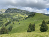
Aiguille running trail


Blue level running trail until Aiguille pass (1815m).
Departure: Tourist Office 1650 - Recoin.
Return trip: Chamrousse 1650 – Aiguille.
Departure: Tourist Office 1650 - Recoin.
Return trip: Chamrousse 1650 – Aiguille.
Intermediate running trail.
Estimated running time for an average speed of 7km/h.
Estimated running time for an average speed of 7km/h.
Opening periodFrom 01/05 to 30/09 daily.
Contact
Aiguille running trail
Chamrousse 1650
38410
Chamrousse
- Spoken language(s) :
- French
Route
 Type of route:
:
Aller / Retour
Type of route:
:
Aller / Retour
 1.6
km (distance)
1.6
km (distance)
 15
minutes (session length)
15
minutes (session length)
 152
metres (positive drop)
152
metres (positive drop)
 151
metres (negative drop)
151
metres (negative drop)
 Chamrousse 1650 - Recoin
 Departure/Arrival
 Point of interest
Circuit n° 1
Resort road access from Grenoble: Rocade Sud > exit no. 2 "Uriage" > Route départementale 111 (RD 111) Seiglières side.
Recommended parking: Parking Henry Duhamel (P7), avenue Henry Duhamel (200 m, approx. 2-minute walk).
Public transport - Chamrousse 1650 - Recoin stop:
- regular bus service all year round: N93 (to/from Grenoble), "Chamrousse 1650" stop (merging former T87, Transaltitude, Destination neige Skibus / nature Estibus 707)
Good to know - another stop less than 500m away (Place de Belledonne, near the Tourist Office):
- transport by reservation on weekdays excluding public holidays: Flexo 57 (to/from Uriage), "Chamrousse - Le Recoin" stop (former TAD TouGo - line G701)
- Mobility :
- Bus stop 500 m away
General informations
- Services :
- Pets allowed
To note
- Grouping by age (EN) :
- Grouping by age (EN)
Photos
Photos