
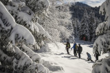
Snowshoeing trail: Pré Gaudet


Stroll in the forest where the magic happens after a beautilful snowfall, a real change of scenery !
From:
- Chamrousse 1600 : 3h30 return 7km and 190m ascending elevation
- Chamrousse 1650 : 3h30 return 7km and 240m ascending elevation
Stroll in the forest where the magic happens after a beautilful snowfall, a real change of scenery !
Look for forest animal prints : roe deer, boar, squirrel, hare...
- Chamrousse 1600 : 3h30 return 7km and 190m ascending elevation
- Chamrousse 1650 : 3h30 return 7km and 240m ascending elevation
Stroll in the forest where the magic happens after a beautilful snowfall, a real change of scenery !
Look for forest animal prints : roe deer, boar, squirrel, hare...
Opening periodFrom 01/12 to 15/04 daily.
Subject to snow conditions.
Subject to snow conditions.
Contact
Snowshoeing trail: Pré Gaudet
Départ du parking du Vernon à Chamrousse 1650.
Chamrousse 1650
38410
Chamrousse
- Spoken language(s) :
- French
- English
Route
 Type of route:
:
BOUCLE
Type of route:
:
BOUCLE
 7
km (distance)
7
km (distance)
 210
minutes (session length)
210
minutes (session length)
 240
metres (positive drop)
240
metres (positive drop)
 Portion with high positive gradient.
 Chamrousse 1600 - Plateau de l'Arselle
 Departure/Arrival
 Point of interest
Circuit n° 1
Departure from the Vernon parking lot in Chamrousse 1650 - Recoin.
Public transport - Chamrousse 1650 - Recoin stop:
- regular bus service all year round: N93 (to/from Grenoble), "Chamrousse 1650" stop [merger of former T87, Transaltitude, Destination nature Skibus / Estibus 707].
Good to know - another stop less than 500m away (Place de Belledonne, near the Tourist Office):
- bus line / shuttle service by reservation on weekdays excluding public holidays: Flexo 57 (to/from Uriage), "Chamrousse - Le Recoin" stop [former TAD TouGo - line G701].
- resort shuttle in winter: "Télécabine (1650)" stop (to/from Chamrousse 1750 - Roche Béranger and Chamrousse 1600 - plateau de l'Arselle/nordic area)
Nearest stop: "Vernon" station shuttle bus stop.
- Mobility :
- Shuttle stop 300 m away
General informations
- Services :
- Pets allowed
- Additional openings :
- Depending on snow conditions
Equipments & Services
- Parking :
- Parking facilities nearby
- Restaurants :
- Catering
Pics
Pics


We also suggest...


