
Snowshoeing trail: Lac Achard by Arselle


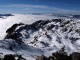
All along your walk, you will have an unobstructed view of the Arselle peat bog (Nordic area) and the Taillefer. At the end of the track, you will be facing the frozen and snow-covered lake : breathtaking scenery !
Leaving from the Nordic area via l'Arselle: 3h30 round trip, 5.8 km and 310 m ascent.
As you hike, you'll enjoy breathtaking views of the Arselle peat bog (Nordic area) and the Taillefer mountain range. At the end of the path, the snow-covered Lac Achard awaits you: a breathtaking landscape!
This peaceful and enchanting place is also a listed site that must be respected.
As you hike, you'll enjoy breathtaking views of the Arselle peat bog (Nordic area) and the Taillefer mountain range. At the end of the path, the snow-covered Lac Achard awaits you: a breathtaking landscape!
This peaceful and enchanting place is also a listed site that must be respected.
Opening periodFrom 01/12 to 15/04 daily.
Subject to snow conditions.
Subject to snow conditions.
Contact
Snowshoeing trail: Lac Achard by Arselle
Départ au plateau de ski nordique de l'Arselle
Chamrousse 1600
38410
Chamrousse
- Spoken language(s) :
- French
- English
Route
 Type of route:
:
BOUCLE
Type of route:
:
BOUCLE
 5.8
km (distance)
5.8
km (distance)
 210
minutes (session length)
210
minutes (session length)
 311
metres (positive drop)
311
metres (positive drop)
 311
metres (negative drop)
311
metres (negative drop)
 Crossing of a Nordic ski run. Portion with high positive gradient.
 Chamrousse 1600 - Plateau de l'Arselle
 Departure/Arrival
 Point of interest
Circuit n° 1
Parking lot along the D111 departmental road, then access on foot via the groomed footpath to the Arselle plateau.
Public transport - Chamrousse 1600 - Plateau de l'Arselle stop:
- resort shuttle: "Plateau de l'Arselle Domaine nordique (1600)" stop (to/from Chamrousse 1650 - Recoin and Chamrousse 17500 - Roche Béranger)
Public transport - Chamrousse 1750 - Roche Béranger stop:
- regular bus service all year round: N93 (to/from Grenoble), "Chamrousse 1750" stop [merger of former bus routes T87, Transaltitude and Destination nature Skibus / Estibus 707].
- bus line / shuttle on reservation weekdays excluding public holidays: Flexo 57 to/from Uriage [former TAD TouGo transport on demand - line G701].
- resort shuttle in winter: "Centre Commercial (1750)" stop (to/from Chamrousse 1650 - Recoin and Chamrousse 1600 - plateau de l'Arselle/nordic area)
Further information at https://www.itinisere.fr
- Mobility :
- Shuttle stop 300 m away
Download
General informations
- Services :
- Pets allowed
- Additional openings :
- Depending on snow conditions
Equipments & Services
- Parking :
- Parking facilities nearby
- Restaurants :
- Catering
Photos
Photos


We also suggest...


