
IGN Grenoble (Chamrousse Belledonne) map - €14.10


Contact
Office de Tourisme
Place de Belledonne
38410
CHAMROUSSE
Presentation
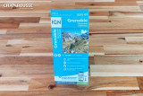
IGN 3335OT Grenoble - Belledonne / Chamrousse map
The ideal topographic map for hiking in Chamrousse, Grenoble and the Belledonne massif
Prepare your hikes with the IGN 3335OT Grenoble - Belledonne / Chamrousse map, an essential tool for exploring the mountains of Isère. Produced by the Institut Géographique National (IGN), this 1:25,000 topographic map is exceptionally accurate and detailed for hiking, mountain biking, trail riding and ski touring.
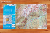
It shows: signposted hiking trails, relief detailed by contour lines, communication routes, tracks and forestry roads, buildings (chalets, huts, refuges, sheds, etc.), natural features (forests, isolated trees, rivers, lakes, springs, etc.) and points of tourist interest.
Areas covered by the IGN 3335OT map: Chamrousse, Grenoble, Belledonne, Corenc, Champ-sur-Drac, Bresson, Domène, Poisat, Eybens, Vif, Le Pont-de-Claix, Venon, Saint-Jean-le-Vieux, Revel, Sainte-Agnès, La Tronche, Saint-Martin-le-Vinoux, Saint-Égrève, Meylan, Saint-Martin-d'Hères, Sassenage, Fontaine, Le Versoud, Seyssinet.
Dimensions: 96 cm x 132 cm / Scale: 1:25,000 (1 cm = 250 m)
On sale at Chamrousse Tourist Office
The ideal topographic map for hiking in Chamrousse, Grenoble and the Belledonne massif
Prepare your hikes with the IGN 3335OT Grenoble - Belledonne / Chamrousse map, an essential tool for exploring the mountains of Isère. Produced by the Institut Géographique National (IGN), this 1:25,000 topographic map is exceptionally accurate and detailed for hiking, mountain biking, trail riding and ski touring.
It shows: signposted hiking trails, relief detailed by contour lines, communication routes, tracks and forestry roads, buildings (chalets, huts, refuges, sheds, etc.), natural features (forests, isolated trees, rivers, lakes, springs, etc.) and points of tourist interest.
Areas covered by the IGN 3335OT map: Chamrousse, Grenoble, Belledonne, Corenc, Champ-sur-Drac, Bresson, Domène, Poisat, Eybens, Vif, Le Pont-de-Claix, Venon, Saint-Jean-le-Vieux, Revel, Sainte-Agnès, La Tronche, Saint-Martin-le-Vinoux, Saint-Égrève, Meylan, Saint-Martin-d'Hères, Sassenage, Fontaine, Le Versoud, Seyssinet.
Dimensions: 96 cm x 132 cm / Scale: 1:25,000 (1 cm = 250 m)
On sale at Chamrousse Tourist Office
Prices
14.10€ each